
The Northwoods Route (BikepackingRoots) is the top pick for long-distance bikepackers, the Tour de Chequamegon suits weekend riders, and CAMBA’s Namekagon and Drummond loops are the go-to gravel bike trails for day riders in the Northwoods. If you want a quick answer before diving into the details, here it is:
Best for day rides: CAMBA Namekagon N2, Drummond D3, Dynamite Pie
Best for weekend bikepacking: Tour de Chequamegon, Valhalla Beach Party
Best for long-distance bikepacking: Northwoods Route, Wisconsin Waterfall Bikepacking Loop
| Route | Best For | Distance | Physical Difficulty | GPX Available |
|---|---|---|---|---|
| Northwoods Route | Long-distance bikepacking | 630 mi | High | Yes (BikepackingRoots) |
| Tour de Chequamegon | Weekend bikepacking | ~110 mi | Medium | Yes (RWGPS) |
| Wisconsin Waterfall Loop | Multi-day bikepacking | 382 mi | High | Yes |
| Valhalla Beach Party | Weekend bikepacking | 82 mi | Medium | Yes |
| Hungry Bear 100 | Day/weekend event ride | 97–100 mi | Medium-High | Yes (event) |
| The Bear 100 (Laona) | Day/weekend event ride | ~100 mi | Medium-High | Yes (event) |
| CAMBA Namekagon N2 | Day ride | 36 mi | Low-Medium | Yes (CAMBA) |
| CAMBA Drummond D3 | Day ride | 46 mi | Medium | Yes (CAMBA) |
Northwoodswisconsin covers lodging and trip-planning resources for all of these starting points, so you can sort your route and your bunk in one place.
Table of Contents
- What are the best gravel biking routes in the Northwoods?
- Signature long routes worth planning a trip around
- Day loops, CAMBA favorites, and event rides
- How to plan your Northwoods gravel trip
- What bike and gear do you need for Northwoods gravel?
- Where do you get GPX tracks and offline maps?
- Safety and wilderness considerations for Northwoods riding
- Key Takeaways
- What riders often get wrong about Northwoods gravel
- Plan your Northwoods gravel trip with Northwoodswisconsin
- Useful sources to bookmark before your ride
- FAQ
What are the best gravel biking routes in the Northwoods?
| Route | Best For | Distance | Physical Difficulty | Technical/Surface | Resupply Frequency | Scenery | GPX |
|---|---|---|---|---|---|---|---|
| Northwoods Route | Long-distance bikepacking | 630 mi | High | Mixed (gravel, two-track, rail trail) | Occasional | Lake Superior, forest, rivers | Yes |
| Tour de Chequamegon | Weekend bikepacking | ~110 mi | Medium | 80%+ gravel, some ATV/singletrack | Frequent (Hayward, Cable) | Pine forest, lakes | Yes |
| Wisconsin Waterfall Loop | Multi-day bikepacking | 382 mi | High | Gravel, forest road, some hike-a-bike | Occasional | Waterfalls, remote forest | Yes |
| Valhalla Beach Party | Weekend bikepacking | 82 mi | Medium | Gravel, sand sections | Sparse | Bayfield Peninsula, Lake Superior | Yes |
| Hungry Bear 100 | Event/day-weekend | 97–100 mi | Medium-High | Mixed gravel | Frequent (event support) | Cable-area forest | Yes |
| The Bear 100 (Laona) | Event/day-weekend | ~100 mi | Medium-High | Mixed gravel/surface | Moderate | Laona-area forest | Yes |
| CAMBA Namekagon N2 | Day ride | 36 mi | Low-Medium | Gravel, forest road | Sparse | Namekagon River corridor | Yes |
| CAMBA Drummond D3 | Day ride | 46 mi | Medium | Gravel, old railroad grade | Sparse | Old-growth forest, North Country Trail | Yes |
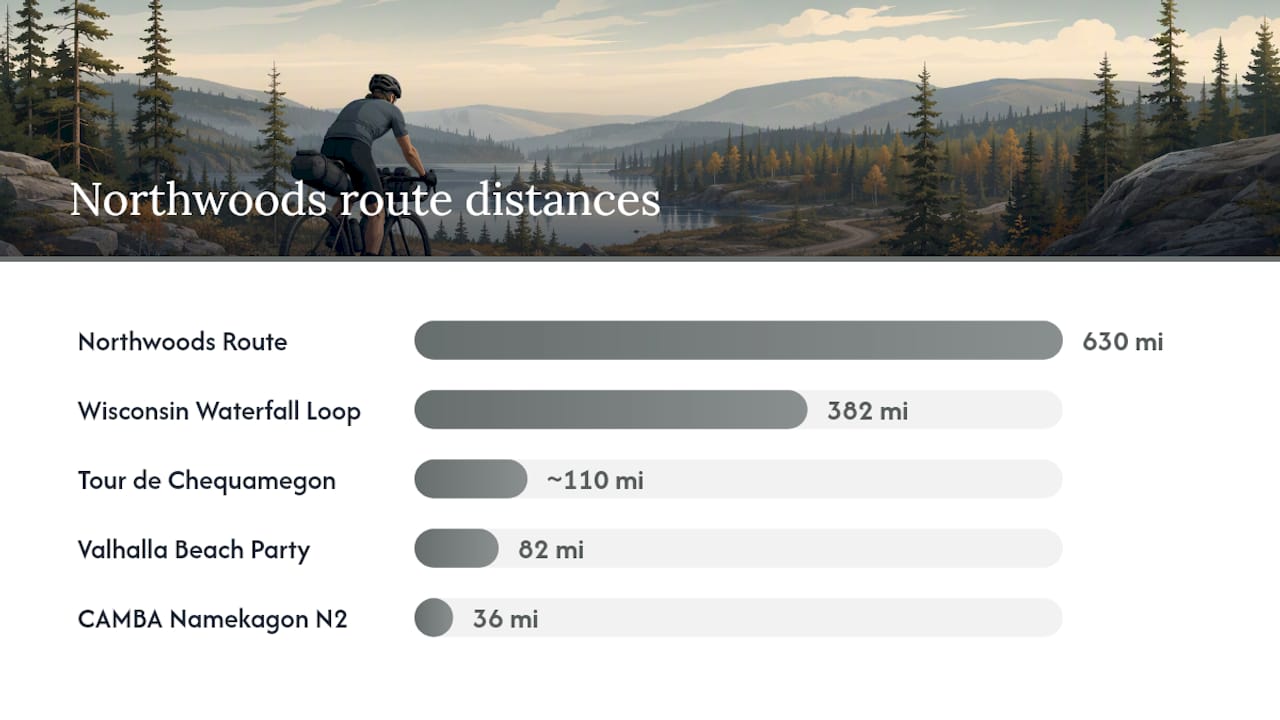
Loaded bikepacking vs. unloaded gravel riding: The Northwoods Route, Wisconsin Waterfall Loop, and Valhalla Beach Party are built for loaded rigs with bags and overnight gear. The CAMBA loops and Tour de Chequamegon work equally well unloaded, and many riders tackle the Tour de Chequamegon as a fast, light weekend loop.
Signature long routes worth planning a trip around
1. Northwoods Route (BikepackingRoots)
The Northwoods Route is a 630-mile loop along the western edge of Lake Superior, mixing gravel, two-track, rail trail, and pavement through northern Wisconsin and Minnesota. BikepackingRoots rates the physical difficulty at roughly 5 out of 10, which sounds manageable until you factor in the cumulative mileage and long service gaps. The recommended bike is a mountain or gravel bike with tires at least 1.75" wide. Most riders complete it in 7–14 days depending on pace and how many side trips they take.
Key resupply towns: Cable, Ashland, Solon Springs, Duluth, Grand Marais. The Wisconsin segment is the heart of the route, rolling through the Chequamegon-Nicolet National Forest on pine-shaded county roads with minimal traffic. Ride it counterclockwise if you want to save the Lake Superior shoreline for the back half. The ideal window is early May through September.
Pro Tip: Download the BikepackingRoots GPX before you leave home and load it onto a dedicated GPS device. Cell coverage disappears for long stretches in the Wisconsin segment, and phone-based navigation is unreliable there.
2. Wisconsin Waterfall Bikepacking Loop
At 382 miles, the Wisconsin Waterfall Bikepacking Loop threads through the northern tier of the state, linking a string of waterfalls in the Ashland County Forest and Chequamegon-Nicolet. The waterfalls cluster in the Mellen and Gurney areas, and a few connector sections involve hike-a-bike on rougher terrain. Plan for dispersed camping and occasional resupply in Mellen, Hurley, and Ashland. This one rewards patience: the payoff is genuine wilderness solitude and some of the most dramatic scenery in the Midwest.
3. Tour de Chequamegon
The Tour de Chequamegon is about 110 miles with over 80% on gravel roads, plus short stretches of ATV trail and CAMBA singletrack. It loops through the Chequamegon-Nicolet National Forest and connects the trail towns of Hayward and Cable, both of which have grocery stores, cafes, and bike-friendly lodging. Most weekend riders complete it in two days with one night of camping. The singletrack alternates add technical variety if you want them, but you can stick to gravel roads throughout.
Pro Tip: Surface conditions on the Tour de Chequamegon change fast after rain. Crusher fines wash out and expose loose rock, so check recent trail reports on the CAMBA site or local Facebook groups before you roll.
4. Valhalla Beach Party (Bayfield Peninsula)
The Valhalla Beach Party loop covers 82 miles on the Bayfield Peninsula, hugging Lake Superior’s south shore with a mix of gravel and sandy sections. The sand stretches near the lakeshore demand wider tires (2.0" or more) and lower pressure. The payoff is beach access, lake swimming, and views of the Apostle Islands. Ride it in July or August for the best chance of a swim stop. Resupply is sparse between Bayfield and Cornucopia, so carry enough food for the full day.
5. Hungry Bear 100 and The Bear 100 (Laona)
These two events double as excellent route templates for non-racers. The Hungry Bear (Cable) offers three distance options: the Climbing Cub at 30 miles, the Snacking Bear at 60 miles, and the Hungry Bear 100 at 97–100 miles. The Bear 100 in Laona runs a similar mixed-surface course of about 100 miles. Both events take place in May and draw a community-focused crowd with strong local hospitality. If you are new to remote Northwoods logistics, riding either event gives you the route experience with event support in place.
Day loops, CAMBA favorites, and event rides
CAMBA Namekagon loops
The Namekagon gravel loops start near the town of Cable and follow county forest roads through the Namekagon River corridor. The N2 is the sweet spot for most riders: 36 miles with 1,328 feet of climbing, enough to feel like a real day out without requiring a full resupply stop. The N3 pushes longer and harder. All three loops carry a “no services” warning for significant stretches, so bring more water and food than you think you need. Elk sightings are genuinely common here, especially in the early morning.
Drummond loops
The Drummond loops start from the small town of Drummond and use an old railroad grade as the backbone. D1 is 15 miles with 505 feet of climbing, a solid introduction. D2 adds distance and a North Country Trail crossing at 20 miles and 557 feet. D3 is the local favorite at 46 miles and 1,781 feet of climbing, rolling through old-growth forest sections that feel genuinely remote. There are no services between the start and finish on D3, so treat it as a self-supported day.
Cable-area day rides
The Cable area packs in several named routes that locals ride on rotation. Dynamite Pie (26 miles) is a crowd favorite for its mix of gravel and forest road with a manageable distance. Pine Stump Jump Off (52 miles) steps up the commitment. Sawmill Bikeraft (19 miles) is the shortest and a good warm-up loop. Parking is available at the Cable Community Farm trailhead. After the ride, Rivers Eatery in Cable is the go-to for a hot meal, and Tilly’s Pie is worth the stop if you time it right.
The Northwoods gravel scene is built on community. Events like the Hungry Bear and The Bear 100 are not just races — they are the reason local riders show up, volunteer, and keep these routes maintained. If you are riding the Northwoods for the first time, attending one of these events in May is the fastest way to get insider knowledge, meet people who know every resupply stop, and understand the logistics before you go solo.
How to plan your Northwoods gravel trip
Seasonality and surface conditions
The practical riding window for long routes runs from early May through September. Early May can bring sticky “peanut butter” mud after snowmelt, especially on two-track and forest roads. Summer dry spells create sandy stretches that demand more tire volume. Rain at any point can wash out crusher fines and expose loose rock, particularly on the Tour de Chequamegon. Peak summer (late June through August) offers the most reliable surfaces for day rides and weekend loops.
Accommodation options
- Dispersed camping in the Chequamegon-Nicolet National Forest is free and legal in most areas. Check dnr.wisconsin.gov for designated campsite rules and any fire restrictions before you go.
- Cabins and resorts near Cable, Hayward, Laona, and Bayfield give you a real bed and a hot shower. Northwoodswisconsin lists resort stays for outdoor lovers near key trailheads, which is worth browsing when you are booking a base camp for multi-day riding.
Transportation and access
- Parking is available at Cable Community Farm, Drummond town trailhead, and most CAMBA loop starts.
- Duluth functions as the main northern hub. Greyhound and Jefferson Lines serve Duluth, and it is a practical drop-off point for riders starting the Northwoods Route from the north.
- Shuttles between Cable and Hayward are occasionally arranged through local bike shops; ask at the shop when you arrive.
- Ferry service to Isle Royale (Voyageur II or Sea Hunter II from Grand Portage, MN) is an option for riders extending into the Lake Superior island system, though that is a separate trip.
Estimated costs for a multi-day trip
- Dispersed camping: free (permit not required in most Chequamegon-Nicolet areas)
- National forest campground: roughly $15–$25 per night
- Cabin or resort lodging: varies widely; budget $80–$200+ per night
- Food and resupply: $20–$40 per day on the trail
- Emergency repair budget: carry $50–$100 for unexpected parts or a taxi to the nearest town
- Event entry (Hungry Bear, The Bear 100): check current registration pages for fees
What bike and gear do you need for Northwoods gravel?
Bike and tire setup
The Northwoods Route guidance is clear: bring a mountain or gravel bike with tires at least 1.75" wide for long and remote routes. For the Valhalla Beach Party’s sandy sections, 2.0" or wider is a smarter call. On the smoother pine-shaded county roads of the Pinery region, a well-set-up gravel bike with 40–45mm tires handles the surface well. The Blue Hills region, by contrast, throws in ridge climbs and rougher surfaces where wider tires and lower pressure pay off.
Tubeless is strongly recommended for any multi-day route. Run lower pressure on sandy and loose sections (18–22 psi for a loaded 2.0" tire), and carry a plug kit plus a spare tube as backup.
Packing checklist by trip length
Day ride:
- Navigation device or phone with offline maps
- 2–3 liters of water (filter or purification tablets as backup)
- Food for the full distance plus an emergency snack
- Basic repair kit (tubes, pump, tire levers, multi-tool, chain link)
- Rain layer and wind shell
Overnight:
- Everything above, plus:
- Bivy or lightweight tent
- Sleeping bag rated to 40°F or lower
- Stove and one pot
- Headlamp with spare batteries
- First aid kit
Multi-day (3+ days):
- Full shelter system
- 4–5 days of food minimum between resupply towns
- Water filter (Sawyer Squeeze or similar)
- Satellite communicator (Garmin inReach or SPOT)
- Spare derailleur hanger, brake pads, and extra chain links
- Warm layers for cool nights (even in July, Northwoods nights drop)
Pro Tip: For multi-day bikepacking in the Chequamegon backcountry, balance tire volume against total pack weight. A heavier load drops your optimal tire pressure, so if you are running 2.0" tires at 20 psi with 20 pounds of gear, you will roll over sandy patches far more easily than a lightly loaded rider on 40mm tires at 35 psi.
Where do you get GPX tracks and offline maps?
The three sources every Northwoods rider should bookmark before leaving home:
- BikepackingRoots Northwoods Route page — downloadable GPX for the full 630-mile loop, plus segment notes and cue sheets. This is the primary navigation file for the long route.
- CAMBA maps — GPX downloads for every Namekagon (N1–N3) and Drummond (D1–D3) loop, plus printable PDF maps. Go to cambatrails.org and download before you lose cell signal.
- RWGPS and Bikepacking.com — the Tour de Chequamegon route file lives on RWGPS and is linked from the Bikepacking.com route page. Download it to your account and sync to your device.
For apps and devices:
- Komoot — works well for planning and navigation, with offline map downloads available in the app.
For redundant navigation, carry a printed paper map of the county forest road network. Save water source POIs and resupply town waypoints to your device before you enter low-cell zones. On the Northwoods Route’s Wisconsin segment, assume no cell service and plan accordingly.
Safety and wilderness considerations for Northwoods riding
Wildlife and food storage
Black bears are common throughout the Chequamegon-Nicolet and surrounding county forests. Store food in a bear canister or hang it at least 10 feet off the ground and 4 feet from the trunk when camping. If you encounter a bear on the trail, make noise, give it space, and do not run. Wolves are present in the Northwoods as well; sightings are rare but possible.
Pro Tip: In remote sections of the Northwoods Route, you are more likely to pass wildlife than other vehicles. That is part of the appeal, but it also means you are genuinely on your own. Carry a satellite communicator on any multi-day route where cell coverage is absent.
Cell coverage and self-sufficiency
Expect intermittent or no cell service across most of the Namekagon and Drummond loops, and for long stretches of the Northwoods Route through the Wisconsin segment. Do not rely on your phone for navigation or emergency contact in these areas. A Garmin inReach or similar satellite communicator is the responsible choice for solo riders on multi-day routes.
Multi-use roads and hunting season
Forest roads in the Chequamegon-Nicolet are shared with ATVs, snowmobiles (in season), and logging trucks. Ride with a bright rear light even during the day, and wear a high-visibility vest or jersey during fall hunting season (mid-September through November). Check Wisconsin DNR hunting season dates before planning a fall trip, and consider an orange vest as standard kit for any October or November ride.
Leave No Trace and camping rules
For dispersed camping in the Chequamegon-Nicolet, pack out all waste, use a camp stove instead of a fire when conditions are dry, and camp at least 200 feet from water sources. Check dnr.wisconsin.gov for current fire restrictions and any designated campsite requirements before your trip. Some areas within the national forest require camping in designated sites only, so confirm the rules for your specific route segment.
Key Takeaways
The Northwoods Route (630 miles) is the definitive long-distance gravel bikepacking circuit in the region, while CAMBA’s Namekagon N2 (36 miles) and Drummond D3 (46 miles) deliver the best day-ride experiences on named, GPX-ready loops.
| Point | Details |
|---|---|
| Match route to trip length | Day riders: CAMBA N2 or D3. Weekend: Tour de Chequamegon or Valhalla. Multi-day: Northwoods Route or Wisconsin Waterfall Loop. |
| Download GPX before you go | BikepackingRoots, CAMBA, and RWGPS all offer free GPX downloads; cell service disappears on most remote segments. |
| Plan resupply carefully | Service gaps on long routes can exceed 50 miles; Cable, Ashland, Duluth, and Hayward are the most reliable resupply towns. |
| Use tires ≥ 1.75" for long routes | Northwoods Route guidance specifies mountain or gravel bike with tires at least 1.75" wide; go wider for sandy Bayfield sections. |
| Northwoodswisconsin for lodging | Browse cabins and resorts near Cable, Hayward, Laona, and Bayfield for base-camp lodging between riding days. |
What riders often get wrong about Northwoods gravel
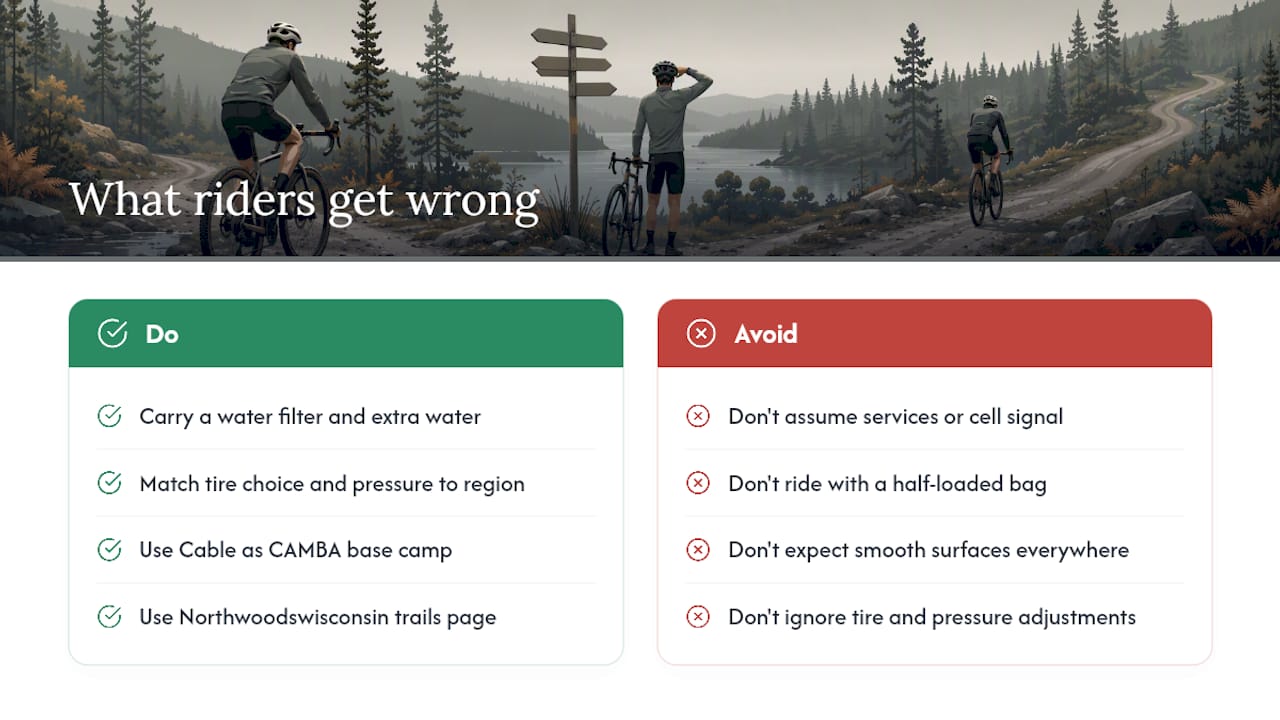
The conventional wisdom says the Northwoods is “easy gravel” because the terrain is not mountainous. That framing misleads a lot of first-timers. The challenge here is not elevation, it is distance and isolation. You can ride 60 miles in the Chequamegon-Nicolet and not pass a single gas station, convenience store, or reliable cell signal. Riders who train on routes with frequent services and then show up for the Northwoods Route with a half-loaded frame bag and no water filter tend to have a rough time.
The other thing people underestimate is surface variability. The Pinery region delivers smooth, pine-shaded county roads that feel almost effortless. Ride into the Blue Hills or a post-rain section of the Tour de Chequamegon, and the surface changes completely. Matching your tire choice and pressure to the specific region you are riding matters more than most pre-trip planning guides suggest.
One local tip worth knowing: Cable is a better base camp than Hayward for most CAMBA loops. The trailheads are closer, the community is smaller and more rider-focused, and you are more likely to get useful local beta from people who rode the route last weekend. If you are planning a multi-day trip and want a comfortable place to land, Northwoodswisconsin’s northern Wisconsin trails page is a good starting point for connecting lodging options to specific trailheads.
Plan your Northwoods gravel trip with Northwoodswisconsin
Sorting out lodging for a multi-day gravel trip is genuinely easier when your route and your bunk are in the same planning window. Northwoodswisconsin lists cabins, resorts, and rentals near every major Northwoods trailhead, from Cable and Hayward to Laona and Bayfield. Idle Hours Resort is a strong pick for riders wanting resort-level comfort near central Northwoods trail access. For groups or families sharing a private space, Anchor Rentals in St. Germain offers cabin-style lodging close to the trail network. The full Northern Wisconsin Recreation hub on Northwoodswisconsin covers camping, trails, and activity resources in one place, so you can build your itinerary without bouncing between a dozen different sites.
Browse lodging options by trailhead town on Northwoodswisconsin and lock in your base camp before the summer calendar fills up.
Useful sources to bookmark before your ride
- Namekagon Gravel | Explore Gravel Biking Today — Chequamegon Area Mountain Bike Association
- Drummond Gravel | Discover Trails Today — Ride and Explore — Chequamegon Area Mountain Bike Association
- Northwoods Route — BikepackingRoots
- Tour de Chequamegon, Wisconsin — BIKEPACKING.com
- Wisconsin gravel biking — The Pinery region — WisconsinGravel.org
- Wisconsin Gravel Biking — Blue Hills region — WisconsinGravel.org
- Chasing the Two Gravel Bears of the Wisconsin Northwoods — Silent Sports
- Recreation — dnr.wisconsin.gov
FAQ
What is the longest gravel biking route in the Northwoods?
The Northwoods Route is 630 miles, looping along the western edge of Lake Superior through northern Wisconsin and Minnesota. GPX is available free from BikepackingRoots.
When is the best time to ride Northwoods gravel routes?
Early May through September is the practical window for most routes. Peak summer (late June through August) offers the most reliable surfaces, though spring mud and sandy late-summer patches are common.
Do I need a mountain bike for Northwoods gravel riding?
For day loops like the CAMBA Namekagon and Drummond routes, a gravel bike with 40–45mm tires works well. For long routes like the Northwoods Route, a mountain or gravel bike with tires at least 1.75" wide is recommended.
Are there beginner-friendly gravel routes in the Northwoods?
Yes. The CAMBA Drummond D1 (15 miles, 505 feet of climbing) and Namekagon N2 (36 miles, 1,328 feet) are accessible starting points. The Hungry Bear event’s Climbing Cub option (30 miles) is another good entry point with event support.
Where can I find lodging near Northwoods gravel trailheads?
Northwoodswisconsin lists cabins, resorts, and rentals near Cable, Hayward, Laona, and Bayfield. The Northern Wisconsin Recreation page is a practical starting point for connecting lodging to specific trailheads.
